
AI-Driven Precision
Crop Protection
Smart aerial crop analysis from drone and satellite data. Save up to 70% on chemical with AI-generated variable rate prescription maps for any brand of sprayer.
CultiWise: Sometimes, Less is More
CultiWise enabling Smart and Sustainable farming with data driven AI prescription maps for any brand
CultiWise is an easy-to-use software platform which allows the creation of prescription maps for spot spray and variable rate application based on drone or satellite data.
The data is processed through CultiWise system. Where weed maps and variable rate maps are created using AI models. These maps are then uploaded into the tractor or sprayer where the prescription can be applied.
Tallis Amos Group is an authorised dealer of CultiWise in the UK and can help set up and support you using CultiWise. Flexible image sources make it ideally suited to the UK climate where cloud cover can affect satellite imagery.
 Tallis Amos Group is the authorised CultiWise dealer for the UK.
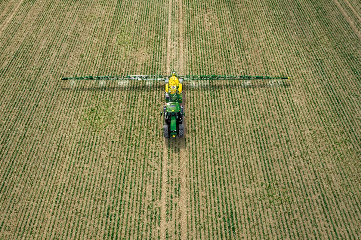
Benefits
The savings stack up for your input bill, your soil and the environment.
Reduce chemical, seeding and fertiliser costs
Calculate the total volume of product needed before application
Compatible with a wide range of sprayers with section control, from 5‑meter boom to individual nozzle sprayers
Detect ‘green-on-brown’ and ‘green-on-green’ weed species with AI imagery
Two Ways to Capture Your Fields
Drone imagery for detail on demand, satellite data across the whole farm.
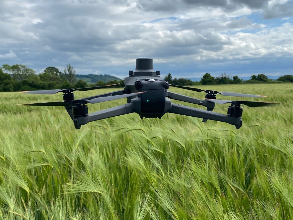
Example of Drone Technology — Mavic 3 Multispectral Drone
Autonomously-flown drones capture detailed multispectral data ready for CultiWise AI to turn into actionable prescription maps.
- 20 MP RGB camera
- 5 multispectral cameras
- Pre-planned flight routes programmed into the drone, supported by CultiWise
- Drone autonomously flies the field
- Data uploaded into CultiWise
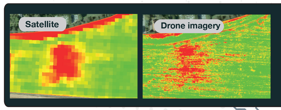
Variable Rate Application from Satellite Data
Cloudy UK skies? No problem. CultiWise blends drone and satellite imagery so the prescription maps keep flowing whatever the weather.
- Satellite data can also be used to create variable rate maps of the field
- Use cases include seed rate, fertiliser, growth regulators and fungicides application maps
- The number of zones and rates can be customised
- Historical images help to create productivity potential zones for each area of the field
How CultiWise Works
From aerial capture to in-cab application in five steps.
Capture Imagery
Programmed drone flight or satellite pass collects high-resolution multispectral imagery of the field, automatically and at the optimum growth stage.
AI Analysis
CultiWise AI models process the imagery, identifying weed species, crop stress and growth variation pixel-by-pixel across every hectare.
Prescription Map
A field-specific variable-rate or spot-spray map is generated, with total product volumes calculated before you set off.
Upload to Sprayer
The map drops straight into the tractor or sprayer terminal. Compatible with John Deere, Case, New Holland, Fendt and more.
Targeted Application
Apply chemistry, fertiliser or seed only where it’s needed. Section control or nozzle-by-nozzle precision delivers the prescription to the millimetre.
Weed & Plant Detection
CultiWise AI models trained for UK fields, UK weeds and UK weather.
Detect emerged weeds against bare ground after harvest or before establishment. The easiest win for spot spraying with the biggest chemical savings.
- Stubble weed mapping from drone or high-res satellite imagery
- Identify volunteer crop plants and grass weeds
- Calculate exact glyphosate / total-herbicide volume before application
- Pair with section-control or individual-nozzle sprayers for spot application
The hardest detection job: identifying weed species against a growing crop. CultiWise AI models are trained specifically on UK conditions and species.
- Detect Anthemis, thistles, docks and grass weeds inside arable crops
- Distinguish weed leaf signatures from crop signatures using multispectral data
- Generate variable-rate herbicide maps targeting only infested zones
- Reduce contact-herbicide spend by up to 70% versus blanket application
Beyond spot spraying. CultiWise builds variable rate maps for the whole input plan, drawn from current and historical imagery.
- Seed rate maps based on productivity-zone analysis
- Variable-rate fertiliser to drive higher yields without over-application
- Growth regulator and fungicide prescription maps
- Custom zone count and per-zone rate configurable per field
For row crops, the Zoneye AI counts individual plants across the field, quantifying establishment and forecasting yield long before harvest.
- Individual plant counts from drone imagery in row crops
- Crop establishment verification against drilling rate
- Early yield forecasting from plant population data
- Identify failed drilling, slug damage or pest pressure zones
See the full detection capability list
- CultiWise AI system allows the identification of specific weed species from drone imagery data
- Works on ‘green on brown’ weeds or ‘green on green’ weeds detection
- Creates a map plan of the weeds and calculates the volume of product needed
- Connects to any brand of software in the tractor
- Product can be directly targeted to the weed with a nozzle section-control sprayer
- Also works with section control boom sprayers at 0.25 to 5 meters
- In row crops the Zoneye AI can count individual plants across the field to verify crop establishment and forecast yield
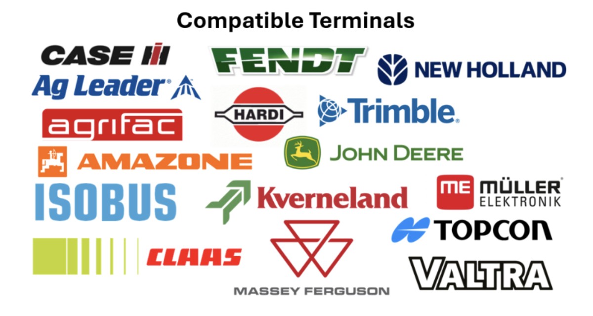
CultiWise works with a wide number of different manufacturers
CultiWise prescription maps drop straight into the in-cab terminals on tractors and sprayers from every major manufacturer.
Plans & Pricing
Two ways to pay: pay as you go with fixed yearly plans or one-off maps, or subscribe per hectare.
Fixed yearly plans that build on each other, or pay per hectare for one-off maps.
| Feature | Free£0 | Start 365£860/year | Plus 365£2,170/year | Pro 365£3,040/year | One-time map creation£4.50/ha |
|---|---|---|---|---|---|
| Farm management | Included | Included | Included | Included | Not included |
| Unlimited satellite field monitoring | Included | Included | Included | Included | Not included |
| Unlimited pre-harvest grain moisture monitoring | Included | Included | Included | Included | Not included |
| Productivity potential maps | Not included | Included | Included | Included | Not included |
| Unlimited variable fertilising | Not included | Included | Included | Included | Not included |
| Unlimited variable seeding | Not included | Included | Included | Included | Not included |
| Unlimited variable growth regulator | Not included | Included | Included | Included | Not included |
| Unlimited variable fungicide | Not included | Included | Included | Included | Not included |
| Unlimited drone zoning: fertilising, growth regulator, fungicide & desiccation | Not included | Not included | Included | Included | Not included |
| Unlimited total herbicide spot spraying (green-on-brown) | Not included | Not included | Included | Included | Not included |
| Green-on-green spot spraying maps | Not included | Not included | Not included | Included | Included |
| AI weed detection | Not included | Not included | Not included | Included | Included |
| Plant counting | Not included | Not included | Not included | Included | Included |
Priced per hectare each year. The dots show which imagery each feature uses on each plan.
| Feature | Free£0 | Start£4.50/ha | Plus£12/ha | Pro£17.50/ha |
|---|---|---|---|---|
| Farm management | Basic satellite | Basic satellite | Basic satellite | Basic satellite |
| Field monitoring | Basic satellite | Basic satellite | Basic satellite, Premium satellite, Drone monitoring | Basic satellite, Premium satellite, Drone monitoring |
| Variable fertilising | Not included | Basic satellite | Basic satellite, Premium satellite, Drone monitoring | Basic satellite, Premium satellite, Drone monitoring |
| Variable seeding | Not included | Basic satellite | Basic satellite, Premium satellite, Drone monitoring | Basic satellite, Premium satellite, Drone monitoring |
| Variable growth regulator | Not included | Basic satellite | Basic satellite, Premium satellite, Drone monitoring | Basic satellite, Premium satellite, Drone monitoring |
| Variable fungicide | Not included | Basic satellite | Basic satellite, Premium satellite, Drone monitoring | Basic satellite, Premium satellite, Drone monitoring |
| Row spray | Not included | Not included | Drone monitoring | Drone monitoring |
| Desiccation | Not included | Not included | Drone monitoring | Drone monitoring |
| Targeted / variable total herbicide | Not included | Not included | Drone monitoring | Drone monitoring |
| Targeted / variable selective herbicide | Not included | Not included | Not included | Drone monitoring |
| Plant counting | Not included | Not included | Not included | Drone monitoring |
| Crop damage analysis | Not included | Not included | Not included | Drone monitoring |
| Spot spray | Not included | Not included | Not included | Drone monitoring |
Plus and Pro include 1 TB of storage a year. Beyond that, storage is charged at £260 per TB a year.
Basic satellite
- 10 m/px resolution
- 2–3 images per week
- Yield potential
Premium satellite
- Daily images, with a higher chance of being cloud-free
- 3× the resolution of basic satellite, for more detailed zones
- Yield potential even on fields under 5 ha
Drone monitoring
- Capture images any time, even in cloudy weather
- Ultra-high resolution, up to 1000× basic satellite
- Many other high-value applications
Frequently Asked Questions
No. CultiWise works with satellite imagery as well as drone data, and TAG Tech can fly your fields for you if you want the higher-resolution drone option. You can also buy or hire a compatible drone (e.g. DJI Mavic 3 Multispectral) directly through TAG.
Almost certainly. CultiWise exports prescription maps in formats compatible with every major in-cab terminal: John Deere, Case IH, New Holland, Fendt, Massey Ferguson and more. From 5m boom section control right down to individual-nozzle precision, we have you covered.
Independent case studies have shown up to 70% reduction on contact herbicides when spot-spraying weeds versus blanket application. Actual savings depend on weed pressure and field. Most growers see meaningful savings in their first season.
Cloud cover is the limiting factor for satellite, but CultiWise blends multiple capture sources and uses historical imagery to fill gaps. Where timing is critical, drone flights give you guaranteed data on demand.
Yes. That’s the whole reason TAG is an authorised UK dealer. The TAG Tech team will help with onboarding, drone flight planning, prescription-map workflow and in-cab compatibility setup. Call 07507 671287 or email cultiwise@tallisamos.co.uk.
References
- Herbicide Spot Spraying — Green on Green Anthemis in Oilseed Rape http://cultiwise.com/case-studies/
- Variable Rate Fertilising — Aim for Higher Yield. http://cultiwise.com/crops/sugar-beet
Ready to Spray Smarter?
Claim your free 15 hectares, see what CultiWise can map for your farm and start saving on your input bill this season.
Authorised UK CultiWise dealer · AI prescription maps · Brand-agnostic · TAG Tech setup & support